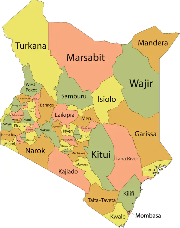
Kenya has a total of 47 counties, which were created by the 2010 constitution. Each county is headed by a County Governor elected by the residents of the County.
The county is also subdivided into constituencies which are further subdivided into wars, represented by the MP and MCA respectively.
Since the implementation of the new system, the devolved system of government has contributed to a more equitable distribution of resources and service delivery across the country.
Counties in Kenya: full list and codes
| Code | County Name | County Headquarters |
| 001 | Mombasa | Mombasa City |
| 002 | Kwale | Kwale |
| 003 | Kilifi | Kilifi |
| 004 | Tana River | Hola |
| 005 | Lamu | Lamu |
| 006 | Taita–Taveta | Mwatate |
| 007 | Garissa | Garissa |
| 008 | Wajir | Wajir |
| 009 | Mandera | Mandera |
| 010 | Marsabit | Marsabit |
| 011 | Isiolo | Isiolo |
| 012 | Meru | Meru |
| 013 | Tharaka-Nithi | Kathwana |
| 014 | Embu | Embu |
| 015 | Kitui | Kitui |
| 016 | Machakos | Machakos |
| 017 | Makueni | Wote |
| 018 | Nyandarua | Ol Kalou |
| 019 | Nyeri | Nyeri |
| 020 | Kirinyaga | Kerugoya |
| 021 | Murang’a | Murang’a |
| 022 | Kiambu | Kiambu |
| 023 | Turkana | Lodwar |
| 024 | West Pokot | Kapenguria |
| 025 | Samburu | Maralal |
| 026 | Trans-Nzoia | Kitale |
| 027 | Uasin Gishu | Eldoret |
| 028 | Elgeyo-Marakwet | Iten |
| 029 | Nandi | Kapsabet |
| 030 | Baringo | Kabarnet |
| 031 | Laikipia | Nanyuki |
| 032 | Nakuru | Nakuru City |
| 033 | Narok | Narok |
| 034 | Kajiado | Kajiado |
| 035 | Kericho | Kericho |
| 036 | Bomet | Bomet |
| 037 | Kakamega | Kakamega |
| 038 | Vihiga | Mbale |
| 039 | Bungoma | Bungoma |
| 040 | Busia | Busia |
| 041 | Siaya | Siaya |
| 042 | Kisumu | Kisumu City |
| 043 | Homa Bay | Homa Bay |
| 044 | Migori | Migori |
| 045 | Kisii | Kisii |
| 046 | Nyamira | Nyamira |
| 047 | Nairobi | Nairobi City |
Counties in Kenya their governors, size, and facts
Since we have provided you with a list of the the Kenyan county numbers from 1 to 47, we delve further into each county’s size, and current leadership.
001: Mombasa
- Governor: Abdullswamad Nassir
- Former province: Coast
- Area in square kilometres: 212.5
If you look at the map of Kenya, you will realise that Mombasa County is a coastal county in the country’s southeastern side, along the Indian Ocean. It is known for tourism. It has luxurious hotels that rake in revenue from local and international tourists.
002: Kwale
Governor: Fatuma Achani Former province: Coast Area in square kilometres: 8,270.3 As explored in the list of the 47 counties in Kenya and their headquarters earlier, Kwale holds code 002. Its capital is Kwale, but its largest town is Ukunda.
003: Kilifi
Governor: Gideon Mung’aro Former province: Coast Area in square kilometres: 12,245.9 Kilifi is also located in the former Coast province. Its capital is Kilifi, and it has an area of 12,245.9 square kilometres. It has some of the most breathtaking tourist sites, like Diani Beach.
004: Tana River
Governor: Dhadho Godhana Former province: Coast Area in square kilometres: 35,375.8 Tana River falls under the former Coast province on the Kenyan map. Its headquarters is Hola, and it is famous because the Tana River flows through, connecting to the Indian Ocean.
005: Lamu
Governor: Issa Timamy Former province: Coast Area in square kilometres: 6,497.7 Lamu occupies an area of 6,497.7 square kilometres. Lamu is an island with numerous historic features. It is a pretty conservative place, and the population is predominantly Muslim.
006: Taita
Taveta Governor: Andrew Mwadime Former province: Coast Area in square kilometres: 17,083.9 Taita Taveta’s capital is Mwatate, and its governor is Andrew Mwadime. It is famous for ranches, sanctuaries, and estates, which boost tourism.
007: Garissa
Governor: Nathif Jama Former province: North Eastern Area in square kilometres: 45,720.2.
Garissa has an area of 45,720.2 square kilometres. Garissa is famous for the large number of refugee camps, including Dadaab.
008: Wajir
Governor: Ahmed Abdullahi Former province: North Eastern Area in square kilometres: 55,840.6 Wajir is located near Somalia and was formerly part of the North Eastern province. Its capital is Wajir, and Ahmed Abdullahi is the county head.
009: Mandera
Governor: Mohamed Adan Khalif Former province: North Eastern Area in square kilometres: 25,797.7 Mandera County is the northeasternmost county in the country. Its capital and largest town is Mandera.
010: Marsabit
Governor: Mohamud Ali Former province: Eastern Area in square kilometres: 66,923.1
Marsabit is one of the counties located in the former Eastern province. Marsabit is famous for bordering the eastern shore of Lake Turkana, and it is also home to a massive chunk of the Chalbi desert.
011: Isiolo
Governor: Abdi Hassan Guyo Former province: Eastern Area in square kilometres: 25,336.1 Isiolo is famous because of the Ewaso Nyiro River, which flows through it. It is a dynamic region that is home to people from multiple communities. A list of the counties in Kenya and their numbers shows its code is 011.
012: Meru
Governor: Kawira Mwangaza Former province: Eastern Area in square kilometres: 7,003.1 Meru is located in the former Eastern province, and it covers an area of 7,003.1 square kilometres. Meru is famous for khat or miraa, a stimulant drug that speeds up the messages between the brain and the body.
013: Tharaka Nithi
Governor: Muthomi Njuki Former province: Eastern Area in square kilometres: 2,609.5 Tharaka Nithi is located in the former Eastern province, and it has an area of 2,409.5 square kilometres. Its capital is Kathwana town, and the county head is Muthomi Njuki.
014: Embu
Governor: Cecily Mbarire Former province: Eastern Area in square kilometres: 2,555.9 Embu sits on 2,555.9 sq. km, and the capital is Embu town. The current governor is Cecily Mbarire, and the county is the largest producer of macadamia in the African Great Lakes.
015: Kitui
Governor: Julius Malombe Former province: Eastern Area in square kilometres: 24,385.1 Kitui is famous for the Nzambani rock, a significant tourist attraction. It has an area of 24,385.1 square kilometres, and the headquarters is Kitui town.
016: Machakos
Governor: Wavinya Ndeti Former province: Eastern Area in square kilometres: 5,952.9 Machakos is an administrative zone in Kenya. It is made of eight constituencies, i.e., Machakos Town, Mavoko, Masinga, Yatta, Kangundo, Kathiani, Matungulu, and Mwala.
017: Makueni
Governor: Mutula Kilonzo Former province: Eastern Area in square kilometres: 8,008.9
Makueni is a county in the former Eastern Province of Kenya. Its capital and largest town is Wote, and Mutula Kilonzo is the governor.
018: Nyandarua
Governor: Moses Badilisha Kiarie Former province: Central Area in square kilometres: 3,107.7 Nyandarua has an area of 3,107.7 square kilometres, and its capital is Ol Kalou town. It is famous for the growing of pyrethrum flowers used in making insecticides.
019: Nyeri
Governor: Mutahi Kahiga Former province: Central Area in square kilometres: 2,361.0 Did you know Nyeri hosts the tomb of Robert Baden Powell, the founder of the Scout movement? Located in the fertile highlands, food and water are plentiful and relatively cheap.
020: Kirinyaga
Governor: Anne Waiguru Former province: Central Area in square kilometres: 1,205.4 Kirinyaga covers an area of 1,205.4 square kilometres, and its capital is Kerugoya. The governor in charge is Ann Waiguru.
021: Murang’a
Governor: Irungu Kang’ata Former province: Central Area in square kilometres: 2,325.8 Murang’a is county 021 in Kenya, and its head is Irungu Kang’ata. Murang’a has an area of 2,325.8 square kilometres, and its capital is Murang’a town.
022: Kiambu
Governor: Kimani Wamatangi Former province: Central Area in square kilometres: 2,449.2 Kiambu is located in the former Central province. It has a population of 2.418 million and covers an area of 2,449.2 square kilometres. Its capital is Kiambu town.
023: Turkana
Governor: Jeremiah Lomurkai Former province: Rift Valley Area in square kilometres: 71,597.8 Turkana occupies an area of 71,597.8 square kilometres and is the country’s largest county by size. There were 926,976 people in this county as of 2019.
024: West Pokot
Governor: Simon Kachapin Former province: Rift Valley Area in square kilometres: 8,418.2 West Pokot is located in the former Rift Valley region and it had a population of 621,241 as per the last census. Its headquarters is Kapenguria, and the current governor is Simon Kachapin.
025: Samburu
Governor: Jonathan Lati Leleliit Former province: Rift Valley Area in square kilometres: 20,182.5 Samburu occupies an area of 20,182.5 square kilometres. The main crops grown in this administrative area are wheat, maize, millet, and beans. A significant population keeps indigenous cows, camels, goats, donkeys, and sheep.
026: Trans-Nzoia
Governor: George Natembeya Former province: Rift Valley Area in square kilometres: 2,469.9 Trans-Nzoia is in the former Rift Valley province, and it covers an area of 2,469.9 square kilometres. Its capital is Kitale, and the governor in charge is George Natembeya.
027: Uasin Gishu
Governor: Jonathan Bii Chelilim Former province: Rift Valley Area in square kilometres: 2,955.3 Uasin Gishu is in the former Rift Valley region, and its headquarters is Eldoret. The current governor is Jonathan Bii Chelilim. This region is famous for its maize plantations.
028: Elgeyo Marakwet
Governor: Wisley Rotich Former province: Rift Valley Area in square kilometres: 3,049.7 Elgeyo Marakwet lies in the former Rift Valley province. It has a population of 454,480, and its capital is Iten. The current head is Wisley Rotich.
029: Nandi Governor: Stephen Sang Former province: Rift Valley Area in square kilometres: 2,884.5 A look at the 47 counties in Kenya and their headquarters shows that Nandi covers an area of 2,884.5 square kilometres, and its capital is Kapsabet. Stephen Sang is the sitting head.
030: Baringo Governor: Benjamin Cheboi Former province: Rift Valley Area in square kilometres: 11,075.3 Baringo is in the former Rift Valley region, and it has a human population of 666,763. It covers an area of 11,075.3 square kilometres, and its headquarters is Kabarnet.
031: Laikipia
Governor: Joshua Irungu Former province: Rift Valley Area in square kilometres: 8,696.1 Laikipia lies within the former Rift Valley province. It has a population of 518,560, and its capital is Rumuruti. The governor in charge here is Joshua Irungu.
032: Nakuru
Governor: Susan Kihika Former province: Rift Valley Area in square kilometres: 7,509.5 Nakuru covers an area of 7,509.5 sq. km, and its capital is Nakuru town. The governor is Susan Kihika, and the county is known for Lake Nakuru and many camping zones.
033: Narok
Governor: Patrick Ole Ntutu Former province: Rift Valley Area in square kilometres: 17,921.2 Narok has a population of 1,157,873, and it covers an area of 17,921.2 square kilometres. The governor is Patrick Ole Ntutu.
034: Kajiado
Governor: Joseph Ole Lenku Former province: Rift Valley Area in square kilometres: 21,292.7 The governor of Kajiado is Joseph Ole Lenku. The region is home to the Maasai people, who are known for preserving their culture and traditions.
035: Kericho
Governor: Erick Kipkoech Mutai Former province: Rift Valley Area in square kilometres: 2,454.5 Kericho is one of the richest counties in Kenya and lies in the former Rift Valley region. It covers an area of 2,454.5 square kilometres, and its capital is Kericho town. It is famous for its extensive tea plantations.
036: Bomet
Governor: Hillary Barchok Former province: Rift Valley Area in square kilometres: 1,997.9 Bomet has a population of 875,689, and it covers an area of 1,997.9 square kilometres. Hillary Barchok is the governor.
037: Kakamega
Governor: Fernandes Barasa Former province: Western Area in square kilometres: 3,033.8 Kakamega is situated in the former Western province. The current governor is Fernandes Barasa.
038: Vihiga
Governor: Wilber K. Ottichilo. Former province: Western Area in square kilometres: 531.3 Vihiga lies in the former Western province, and it had a population of 590,013 as of 2019. The governor is Wilber K. Ottichilo, and Mbale is the headquarters.
039: Bungoma
Governor: Ken Lusaka Former province: Western Area in square kilometres: 2,206.9 This administrative region lies in the former Western province. Its headquarters are in Bungoma town, and the governor is Ken Lusaka.
040: Busia
Governor: Paul Otuoma Former province: Western Area in square kilometres: 1,628.4 Busia’s headquarters are in Busia town, and the governor is Paul Otuoma. It is famous as a border trading centre between Uganda and Kenya.
041: Siaya
Governor: James Orengo Former province: Nyanza Area in square kilometres: 2,496.1 Siaya town is the county headquarters of this county. The governor is James Orengo.
042: Kisumu
Governor: Anyang’ Nyong’o Former province: Nyanza Area in square kilometres: 2,009.5 Kisumu is famous for Lake Victoria. The governor in charge is Professor Anyang’ Nyong’o.
043: Homa Bay
- Governor: Gladys Wanga
- Former province: Nyanza
- Area in square kilometres: 3,154.7
Homa Bay is within the former Nyanza region, and it covers an area of 3,154.7 square kilometres. The governor in charge is Gladys Wanga.
044: Migori
Governor: Ochillo Ayacko Former province: Nyanza Area in square kilometres: 2,586.4 Migori is found in the former Nyanza province, and its headquarters is Migori town. The governor is Ochillo Ayacko.
045: Kisii
Governor: Simba Arati Former province: Nyanza Area in square kilometres: 1,317.9 Kisii is famous for the production of bananas. This county is situated in the former Nyanza region, and it covers an area of 1,317.9 square kilometres.
046: Nyamira
Governor: Amos Nyaribo Former province: Nyanza Area in square kilometres: 912.5 Nyamira is located in the former Nyanza region. It covers an area of 912.5 sq. km, and its capital is Nyamira town. The sitting governor is Amos Nyaribo.
047: Nairobi
Governor: Johnson Sakaja Former province: Nairobi Area in square kilometres: 694.9 Nairobi County has a population of over four million people. Its capital is Nairobi city. It is a metropolitan region and the capital city of Kenya.
Frequently asked questions about the 47 counties in Kenya
How many counties are in Kenya?
Kenya has 47 counties, each with a county government.
Which is the biggest county in Kenya?
The biggest county by size is Turkana which covers an area of 71,597.8 square kilometres. On the other hand, the biggest one by population is Nairobi, with a human population of 4,397,073 as per the 2019 census.
Which is the smallest county in Kenya?
The smallest county in Kenya by size is Mombasa. It occupies an area of 212.5 kilometres squared.
How many counties are in central Kenya?
There are five counties in central Kenya. These are:
- Murang’a,
- Kiambu,
- Nyandarua,
- Nyeri, and
- Kirinyaga.